
In the face of an unprecedented wildfire season, timely insights are more necessary than ever to accurately assess the risk posed by climate induced wildfires.
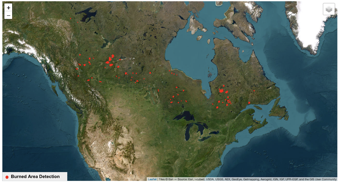
Canada is currently grappling with an unprecedented wildfire season characterized by a surge in both the geographic reach and intensity of fires since March of this year. The resulting devastation has already exceeded the size of the Netherlands, with notable impacts witnessed in Alberta, Nova Scotia, Ontario, and Quebec, where substantial conflagrations have emerged. In June alone, Kayrros detected a staggering 237 fires across Canada, engulfing a surface area of 57,600km². This represents a 282% increase in fire activity between May and June.

Burned area detections based on satellite data as detected by Kayrros across Canada as of 24th June 2023; Source: background is ESRI ‘Copyright Text: Source: Esri, Maxar, Earthstar Geographics, and the GIS User Community’
The reverberations of these wildfires extend far beyond Canada’s borders, evident in the widespread haze and pollution blanketing major North American metropolitan areas like New York City and Chicago, leading to severe air quality index (AQI) rankings globally. The relentless nature of these fires has placed significant strain on available resources, jeopardizing not only human lives but also protected forests and private properties. These alarming developments serve as a stark reminder of the serious impact of climate change, reflecting a distressing upsurge in both the frequency and severity of wildfires.
Amidst these challenges, the utilization of satellite technology, combined with data fusion, machine learning, and AI, has emerged as an indispensable tool for governments, financial institutions, and insurance companies seeking to bolster their preparedness for wildfire seasons in countries prone to such disasters. The Kayrros Wildfire Risk Monitor exemplifies this fusion of advanced technologies, providing an integrated approach to assessing risk, monitoring active wildfires, and quantifying post-fire damage. For instance, Kayrros detected the initiation of fires in the Waswanipi Lake region of Canada on June 2, 2023, and these fires continue to be active. Leveraging Kayrros’ damage assessment technology, approximately 77,400 hectares of land have now been identified as burnt due to these fires.
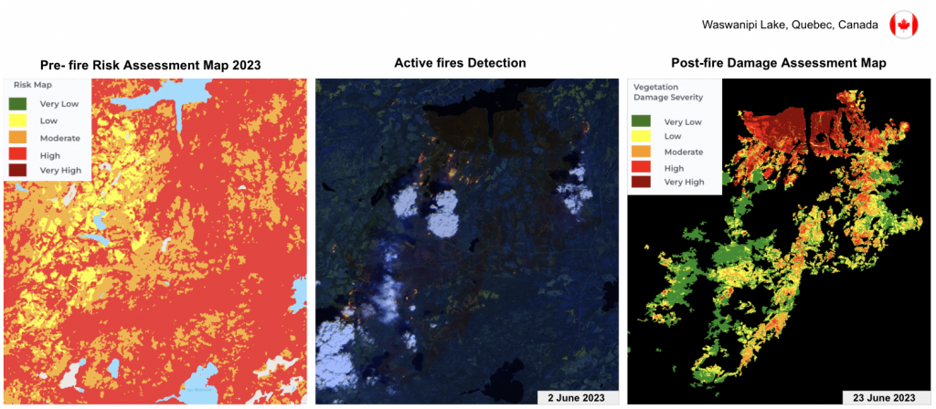
Image: Prefire risk map, active fires detection during fire, and post-fire damage assessment of forest fires near Waswanipi Lake, Quebec, Canada detected using satellite data and processed by Kayrros. “Active fires Detection” sourced from Sentinel-2
The evident pervasiveness of wildfires, as evidenced by the alarming escalation in fire activity and the wide-reaching consequences, underscores the pressing need for enhanced insights into risk assessment and the monitoring of affected areas. By harnessing the power of satellite technology, data fusion, machine learning, and AI, tools such as Wildfire Risk Monitor assume a pivotal role in confronting the escalating frequency and severity of wildfires. Through the adoption of this integrated approach, we can cultivate a more comprehensive understanding of the intricate dynamics of wildfire occurrences, enabling us to develop and implement more effective preparedness and mitigation strategies. By leveraging advanced technologies and deploying robust monitoring systems, we address the multifaceted challenges posed by climate change, safeguarding people, ecosystems and assets in the face of this escalating wildfire crisis.