WHAT IS VEGETATION MANAGEMENT FOR RIGHT-OF-WAY OPERATORS?
Kayrros Vegetation management for Right-of-Way operators leverages satellite data to evaluate the risk of vegetation encroachment close to networks and infrastructures. Prevent and anticipate risks with near-realtime analysis to save resources and increase your flexibility.
///
WHY IS OUR VEGETATION MANAGEMENT FOR RIGHT-OF-WAY OPERATORS UNIQUE?

A regular
update…
A unique Kayrros combination of satellite technologies with other ground and aerial sensors provides monthly to daily updates of vegetation encroachment that might impact operations.

…covering the entire
network remotely
Kayrros satellite technology gives a view of the entire network without deploying ground sensors or observation crews, thereby enabling sizeable optimization of inspection operations.
///
OUR VEGETATION MANAGEMENT FEATURES
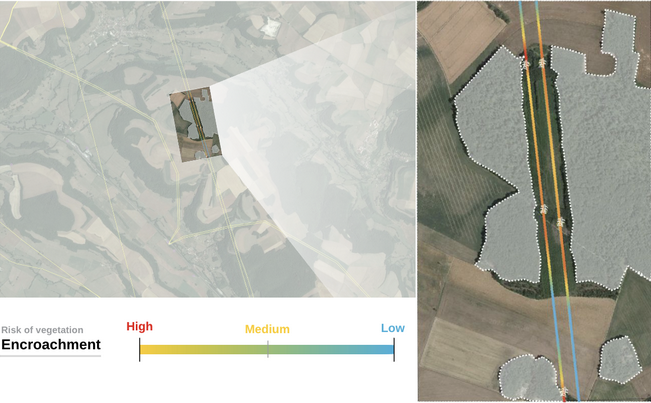
Encroachement risk evaluation
Locate the areas with the higher risks of encroachment close to your network.
///
WHAT DO YOU GET?

Dashboards
Kayrros provides a tailor-made monitoring dashboard to analyze and prevent the risks
Multiplatform alert system
Receive targeted alerts according to your presets program of potential threats to deploy an intervention team
///
OUR OTHER PRODUCTS
Vegetation Clearing

Maximize your operational efficiency by knowing the vegetation index around buildings and infrastructures exposed to fire risk
Wildfire Risk Monitor
Measure more accurately the susceptibility to wildfire, reinforce prevention, prepare operations and monitor wildfire
Wildfire Risk Monitor

Measure risk more accurately and reduce loss ratios with unique wildfire risk modeling, fire monitoring and damage assessment
///
RECENT POSTS
The Global Methane Pledge, Three Years On: Partial Progress Report
Kayrros Carbon Watch introduces EU carbon emissions forecasts

